 Lýsigagnagátt
Downloadable Data
Type of resources
Available actions
Topics
INSPIRE themes
Keywords
Contact for the resource
Provided by
Years
Formats
Representation types
Update frequencies
Scale
Resolution
-

The Corine Land Cover datasets CLC2000, CLC2006 and CLC change 2000-2006 areproduced within the frame of the GMES land monitoring project. Corine Land Cover (CLC) provides consistent information on land cover and land cover changes across Europe. This inventory was initiated in 1985 (reference year 1990) and established a time series of land cover information with updates in 2000 and 2006.CLC products are based on photointerpretation of satellite images by national teams of participating countries - the EEA member and cooperating countries – following a standard methodology and nomenclature with the following base parameters: 44 classes in the hierarchical three level Corine nomenclature; minimum mapping unit (MMU) for status layers is 25 hectares; minimum width of linear elements is 100 metres; minimum mapping unit (MMU) for Land Cover Changes (LCC) for the change layers is 5 hectares. The resulting national land cover inventories are further integrated into a seamless land cover map of Europe.Land cover and land use (LCLU) information is important not only for land change research, but also more broadly for the monitoring of environmental change, policy support, the creation of environmental indicators and reporting. CLC datasets provide important datasets supporting the implementation of key priority areas of the Environment Action Programmes of the European Union as protecting ecosystems, halting the loss of biological diversity, tracking the impacts of climate change, assessing developments in agriculture and implementing the EU Water Framework Directive, among others.More about the Corine Land Cover (CLC) and Copernicus land monitoring data in general can be found at http://land.copernicus.eu/.
-

Corine Land Cover (CLC) 2012 and CLC change 2006-2012 are two of the datasets produced within the frame of the Initial Operations of the Copernicus programme (the European Earth monitoring programme previously known as GMES) on land monitoring.Corine Land Cover (CLC) provides consistent information on land cover and land cover changes across Europe. This inventory was initiated in 1985 (reference year 1990) and established a time series of land cover information with updates in 2000, 2006 and 2012 being the last one. CLC products are based on photointerpretation of satellite images by national teams of participating countries - the EEA member and cooperating countries – following a standard methodology and nomenclature with the following base parameters: 44 classes in the hierarchical three level Corine nomenclature; minimum mapping unit (MMU) for status layers is 25 hectares; minimum width of linear elements is 100 metres; minimum mapping unit (MMU) for Land Cover Changes (LCC) for the change layers is 5 hectares. The resulting national land cover inventories are further integrated into a seamless land cover map of Europe. Land cover and land use (LCLU) information is important not only for land change research, but also more broadly for the monitoring of environmental change, policy support, the creation of environmental indicators and reporting. CLC datasets provide important datasets supporting the implementation of key priority areas of the Environment Action Programmes of the European Union as protecting ecosystems, halting the loss of biological diversity, tracking the impacts of climate change, assessing developments in agriculture and implementing the EU Water Framework Directive, among others.More about the Corine Land Cover (CLC) and Copernicus land monitoring data in general can be found at http://land.copernicus.eu/.
-
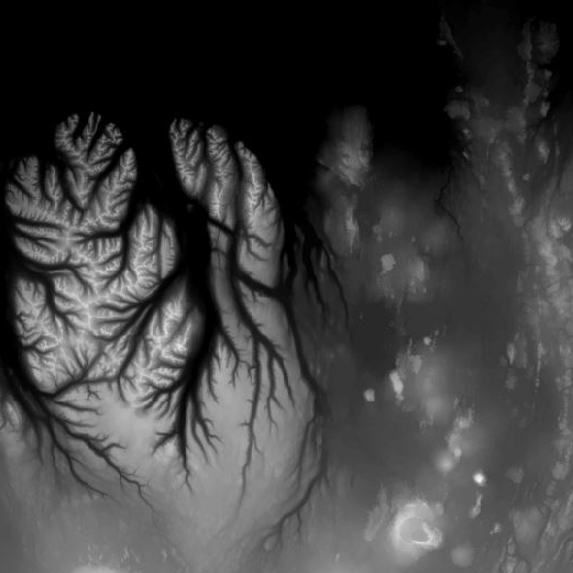
Landmælingar Íslands hafa unnið nýtt landhæðarlíkan af Íslandi. Um uppfærslu á eldra líkani er að ræða þar sem nýleg gögn af ólíkum uppruna þekja um 39.100 km2 eða um 38% landsins. Stærsta samfellda uppfærslan nær frá Suðurlandi til norðausturs, austur fyrir Egilsstaðir.Hæðarlíkanið hefur 10 x 10 m myndeiningar. Helsu nýleg gögn eru (sjá staðsetningu á meðfylgjandi smámynd hér fyrir neðan): 1) IPY-Lidargögn fyrir jökla landsins frá árunum 2007-2012, 15144 km2, LE90: 2,65 m. 2) Gögn úr 5-m-hæðarlínum, 10736 km2, LE90: 3,9 m. 3) Emisar radargögn, 4536 km2, LE90: 3,2 m. 4) Gögn úr 10-m-hæðarlínum, 2938 km2, LE90: 8,48 m, 5) SwedeSurvey photogrammetry gögn, 1433 km2, LE90: 2,60 m, 6) Gögn úr mælikvarða 1:25.000, 1152 km2, LE90: 3,8 m, 7) Bresk lidargögn (Dr. Susan Conway, Open University), 532 km2, LE90: 0,96-4,63 m. Líkaninu fylgir hæðarskygging, þ.e. upphleypt mynd af landinu en slíkar myndir eru gjarnan notaðar sem undirlag til að draga fram eða leggja áherslu á landslag. The National Land Survey of Iceland has made a new DTM of Iceland. The DTM is an upgrade of an earlier DTM where recent data, that vary in origin, cover 39.100 km2 or some 38% of the country. The DEM has pixel resolution of 10 x 10 m with. The main recent data are (see location on figure below): 1) IPY-lidar data for the glaciers of Iceland (surveyed in the years 2007 to 2012), 15144 km2, LE90: 2,65 m. 2) Data from 5-m-contour lines, 10736 km2, LE90: 3,9 m. 3) Emisar radar data, 4536 km2, LE90: 3,2 m. 4) Data from 10-m-contour lines, 2938 km2, LE90: 8,48 m, 5) SwedeSurvey photogrammetic data, 1433 km2, LE90: 2,60 m, 6) 1:25.000 contour data, 1152 km2, LE90: 3,8 m, 7) British lidar data (courtesy of Dr. Susan Conway, Open University), 532 km2, LE90: 0,96-4.63 m.The DTM is accompanied by a hillshade or a relief image of Iceland. Hillshade images are commonly used as a layer beneath maps or data to emphasize landscape.
-

Gögnin sýna hvar bráðamóttökur, læknavaktir og heilsugæslustöðvar eru staðsettar á landinu. Um er að ræða samstarfsverkefni Embættis landlæknis og heilsugæslunnar á höfuðborgarsvæðinu.
-

Strandlínulagið inniheldur bæði línu- og flákalag og er strandlína landsins sýnd auk eyja og skerja.Í fitjuklasanum is50v_strandlina_linur er strandlína landsins, eyja og skerja sýnd. Hægt er að sjá hvort línan tilheyrir eyjum eða skerjum. Í laginu is50v_strandlina_flakar er strandlína landsins, eyja og skerjar sýnd.
-

Eftirfarandi landshlutar eru sóttvarnaumdæmi, sbr. reglugerð 387/2015: Höfuðborgarsvæðið (Reykjavíkurborg, Seltjarnarnesbær, Kópavogsbær, Garðabær, Hafnarfjarðarkaupstaður, Mosfellsbær, Kjósarhreppur og fyrrum sveitarfélagið Þingvallasveit). Vesturland (Akraneskaupstaður, Hvalfjarðarsveit, Skorradalshreppur, Borgarbyggð, Eyja- og Miklaholtshreppur, Snæfellsbær, Grundarfjarðarbær, Helgafellssveit, Stykkishólmsbær, Dalabyggð, Reykhólahreppur, Strandabyggð, Kaldrananeshreppur, Árneshreppur og Húnaþing vestra). Vestfirðir (Vesturbyggð, Tálknafjarðarhreppur, Ísafjarðarbær, Bolungarvíkurkaupstaður og Súðavíkurhreppur). Norðurland (Húnavatnshreppur, Blönduósbær, Skagabyggð, Sveitarfélagið Skagaströnd, Sveitarfélagið Skagafjörður, Akrahreppur, Fjallabyggð, Dalvíkurbyggð, Hörgársveit, Eyjafjarðarsveit, Akureyrarkaupstaður, Svalbarðsstrandarhreppur, Grýtubakkahreppur, Þingeyjarsveit, Norðurþing, Tjörneshreppur, Skútustaðahreppur, Svalbarðshreppur og Langanesbyggð að frátöldum fyrrum Skeggjastaðahreppi). Austurland (Vopnafjarðarhreppur, Fljótsdalshérað, Fljótsdalshreppur, Borgarfjarðarhreppur, Seyðisfjarðarkaupstaður, Fjarðabyggð, Breiðdalshreppur, Djúpavogshreppur og fyrrum Skeggjastaðahreppur). Suðurland (Sveitarfélagið Ölfus, Hveragerðisbær, Grímsnes- og Grafningshreppur, Bláskógabyggð að frátöldu fyrrum sveitarfélaginu Þingvallasveit, Hrunamannahreppur, Sveitarfélagið Árborg, Flóahreppur, Ásahreppur, Skeiða- og Gnúpverjahreppur, Rangárþing ytra, Rangárþing eystra, Mýrdalshreppur, Skaftárhreppur, Sveitarfélagið Hornafjörður og Vestmannaeyjabær). Suðurnes (Sandgerðisbær, Sveitarfélagið Garður, Reykjanesbær, Grindavíkurbær og Sveitarfélagið Vogar).
-

The Corine Land Cover datasets CLC2000, CLC2006and CLC change 2000-2006areproduced within the frame of the GMES land monitoringproject.Corine Land Cover (CLC) provides consistent information on land cover and land cover changes across Europe. This inventory was initiated in 1985 (reference year 1990) and established a time series of land cover information with updates in 2000 and 2006.CLC products are based on photointerpretation of satellite images by national teams of participating countries - the EEA member and cooperating countries – following a standard methodology and nomenclature with the following base parameters: 44 classes in the hierarchical three level Corine nomenclature; minimum mapping unit (MMU) for status layers is 25 hectares; minimum width of linear elements is 100 metres; minimum mapping unit (MMU) for Land Cover Changes (LCC) for the change layers is 5 hectares. The resulting national land cover inventories are further integrated into a seamless land cover map of Europe.Land cover and land use (LCLU) information is important not only for land change research, but also more broadly for the monitoring of environmental change, policy support, the creation of environmental indicators and reporting. CLC datasets provide important datasets supporting the implementation of key priority areas of the Environment Action Programmes of the European Union as protecting ecosystems, halting the loss of biological diversity, tracking the impacts of climate change, assessing developments in agriculture and implementing the EU Water Framework Directive, among others.More about the Corine Land Cover (CLC) and Copernicus land monitoring data in general can be found at http://land.copernicus.eu/.
-
Í markalaginu eru ýmis mörk lands og eru þetta allt flákalög og þau sýna eftirfarandi: skiptingu landsins eftir sveitarfélögum, skiptingu landsins eftir umdæmi sýslumanna, lögregluumdæmi og skiptingu landsins í dómstóla í héraði.
-

Landinu skal skipt upp í eftirfarandi heilbrigðisumdæmi, sbr. reglugerð 387/2015: Heilbrigðisumdæmi höfuðborgarsvæðisins. Heilbrigðisumdæmi Vesturlands. Heilbrigðisumdæmi Vestfjarða. Heilbrigðisumdæmi Norðurlands. Heilbrigðisumdæmi Austurlands. Heilbrigðisumdæmi Suðurlands. Heilbrigðisumdæmi Suðurnesja. Í heilbrigðisumdæmum landsins starfa eftirfarandi heilbrigðisstofnanir: Heilsugæsla höfuðborgarsvæðisins, innan heilbrigðisumdæmis höfuðborgarsvæðisins. Heilbrigðisstofnun Vesturlands, innan heilbrigðisumdæmis Vesturlands. Heilbrigðisstofnun Vestfjarða, innan heilbrigðisumdæmis Vestfjarða. Heilbrigðisstofnun Norðurlands, innan heilbrigðisumdæmis Norðurlands. Heilbrigðisstofnun Austurlands, innan heilbrigðisumdæmis Austurlands. Heilbrigðisstofnun Suðurlands, innan heilbrigðisumdæmis Suðurlands. Heilbrigðisstofnun Suðurnesja, innan heilbrigðisumdæmis Suðurnesja.
-

Corine Land Cover (CLC) 2012 and CLC change 2006-2012 are two of the datasets produced within the frame of the Initial Operations of the Copernicus programme (the European Earth monitoring programme previously known as GMES) on land monitoring. Corine Land Cover (CLC) provides consistent information on land cover and land cover changes across Europe. This inventory was initiated in 1985 (reference year 1990) and established a time series of land cover information with updates in 2000, 2006 and 2012 being the last one. CLC products are based on photointerpretation of satellite images by national teams of participating countries - the EEA member and cooperating countries – following a standard methodology and nomenclature with the following base parameters: 44 classes in the hierarchical three level Corine nomenclature; minimum mapping unit (MMU) for status layers is 25 hectares; minimum width of linear elements is 100 metres; minimum mapping unit (MMU) for Land Cover Changes (LCC) for the change layers is 5 hectares. The resulting national land cover inventories are further integrated into a seamless land cover map of Europe.Land cover and land use (LCLU) information is important not only for land change research, but also more broadly for the monitoring of environmental change, policy support, the creation of environmental indicators and reporting. CLC datasets provide important datasets supporting the implementation of key priority areas of the Environment Action Programmes of the European Union as protecting ecosystems, halting the loss of biological diversity, tracking the impacts of climate change, assessing developments in agriculture and implementing the EU Water Framework Directive, among others.More about the Corine Land Cover (CLC) and Copernicus land monitoring data in general can be found at http://land.copernicus.eu/.